In the bad old days—say, around 2500 B.C.—the pharaohs didn’t have to trouble themselves about labor costs, equipment expenses, or the duration of a project. When building the pyramids of Giza, they could press gang Egyptians from all walks of life, not just slaves, into service. Workers quarried and hewed sandstone into massive blocks with tools made of copper, the hardest metal known to the kingdom, then heaved millions of tons of stone into place, using nothing but wood and ropes. And if it took decades or more to complete, who dared to complain?
Today’s masonry contractor doesn’t have the ancient luxury of free labor. Time is money, and so are materials and equipment. To bid successfully on a job and still make a profit, contractors need all the help they can get. Any tool that can make the design lifecycle more efficient—bidding, estimating, pre-design, field measurement and validation, design adjustment, final approval, and go live—should be a welcome and integral part of the process.
Searching for that tool, some contractors may think of images from satellites and drones. The first has been around for decades, but really isn’t appropriate for masonry work. Reasons: It doesn’t provide clear enough pictures; it’s not updated frequently enough; it doesn’t offer “leaf-off” views and, so, tree canopies can obscure external building details; and its 3-D perspectives are so artificially stylized that important features get lost.
Drones offer very sharp imagery and can be quite helpful for specific kinds of projects. But they, too, have drawbacks. They require specialized skills to pilot and operate. They’re expensive to buy and maintain. They’re tough to get permits for, especially in downtown areas. And their images take time to be processed, stored, and published.
High-resolution aerial imagery is an ideal tool for restoration and remodeling work, as well as for new construction. Innovators in this field, like Nearmap, aren’t simply capturing hyper-clear views of the ground from cameras mounted in airplanes. They’re also creating tools that allow contractors to “translate” images into the data and vocabulary they speak.
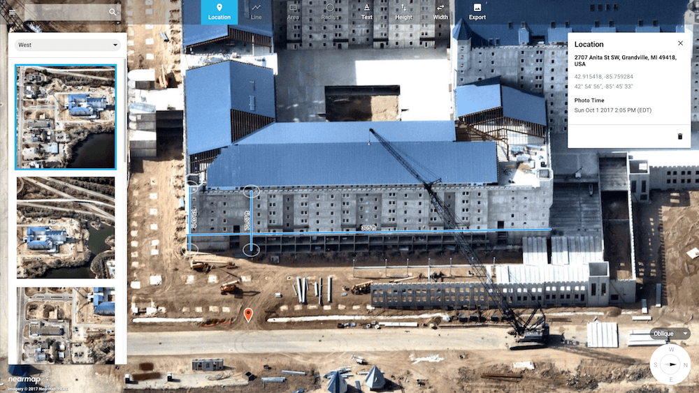
Aerial imagery has other advantages. It provides images at resolutions multiple times sharper than satellite pictures, with a consistent spec at less than 3 inches. It offers a variety of useful perspectives—vertical, panoramic, and oblique—which, along with an interface such as MapBrowser or another third-party mapping tool, allows masonry experts to see clearly, analyze change over time, and measure and estimate with pinpoint precision.

With multiple flybys every year of high-density regions, aerial imagery gives a true snapshot of most areas in the U.S. in all seasons, with and without leaves. Chances are, too, that contractors won’t have to request a special flight. Multi-perspective imagery captured on a continuous basis is rapidly processed and published in the cloud. That means that businesses get near-immediate access to aerial maps without processing and maintenance costs. Nearmap’s cloud-based service offers easy access to these archived images. With a couple of clicks from a desktop or swipes on a tablet at the office, contractors can get a precise birds’-eye view of a site—before even visiting the location for a closer examination. It saves hours of driving time.
What does this mean for the masonry business? Aerial imagery can help with:
- inspecting existing buildings;
- planning where to store scaffolding and materials, create vehicle and equipment access, as well as scope sites for new construction;
- enabling smart logistics;
- estimating time and materials’ costs;
- deploying personnel and equipment;
- minimizing, risk, waste, and error;
- monitoring quarries and supply levels;
- enabling more informed decisions along each stage of a project.
Mason professionals aren’t architects, but they often have to think like them, focusing on existing designs or detailed plans for new construction. Utilizing the panoramic function of aerial imagery, masonry contractors can get a pretty good idea not just of the exterior of the targeted building, zooming in and out of areas, but of the architectural styles of surrounding structures, as well.
What colors of brick and stone are most likely to be needed? Unless it’s a historic landmark where materials must be an exact match, are granite or limestone an absolute necessity? Or will a less expensive substitute, at half the price, serve just as well for restoring a damaged area or building out an expansion? The imagery can help make a preliminary assessment.
Oblique imagery, coupled with easy-to-use tools available in solutions like Nearmap’s MapBrowser, offer precise measurements of the height and width of an affected area. It’s easy to figure out just how much material will be required to repair a damaged corner, arch, window, doorway, or an entire façade. Getting a fix on those costs upfront can help generate accurate initial estimates and prepare at least a baseline in the event of cost overruns.
What about projecting direct labor costs? Obliques, in conjunction with MapBrowser, can help here, too. If you know the precise dimensions of a job, you can predict with a high degree of accuracy how many hours—and workers—it will take to complete a job. The blend of vertical and oblique views, easily accessible from the same tool, allows masonry professionals to navigate nimbly through landscapes and property boundaries, quickly visualize ground features, and plan with unprecedented speed.
But as every masonry contractor knows, estimates are just the start of a proposal to a client. Getting to know the anticipated work area and planning logistics are also key. If the potential job is large enough, where will the lay-down yards be? How about staging areas? What are the best ways vehicles and equipment can enter and exit the site?

For projects in a densely developed area, whether residential or commercial, high-resolution aerial imagery provides a detailed snapshot of significant facts on the ground. It can pinpoint a culvert or a manhole and any overhead obstructions like powerlines and trees. Overlaying a survey map onto the imagery can highlight the location of gas pipelines, buried cable and electrical infrastructure, sewer and water lines, and stakes that must be avoided. It can also point out roads and other means of access to a job site. Aerial imagery (obliques plus, say, a tool like MapBrowser) can be used to annotate the pictures—arrows here, notes there—and then shared with and printed out for those who need to know.
Armed with this kind of visual information, a contractor can plan the most sensible routes for trucks carrying heavy loads to the site—and create a reasonable schedule for each subcontractor that ensure a sensible work flow. Timing is so often critical. So is knowing that you won’t run out of materials.
Once these potential hindrances and approaches have been accounted for, contractors can then have a much better idea of how to organize the job site for maximum safety and efficiency. They know where to pile bricks and stones and how to bring in and store heavy front-load haulers and, if necessary, garbage trucks, along with any other kind of equipment. They can note exact distances between, say, the location of the bricks and the area of repair, renovation, or new construction, recalculating labor expenses by timing the distance of an average full wheelbarrow haul, and adjusting for improved productivity and cost savings.
If a job requires scaffolding or seismic retrofitting, a sharp vertical view is indispensable. It can suggest just how far out from a building edge the structures must be built. If the land slopes or buckles under cracked pavement, or if there are other variations in contact surfaces, the crew can assess and prepare how to deal with irregular surfaces—along with standard lift heights—before it actually starts construction.
Accurate estimates, as contractors know all too well, can mean the difference between a profit and a loss. They can help avoid unexpected (and unpleasant) surprises. Having an authentic and verifiable picture of a potential site—and being able to switch effortlessly from oblique to panoramic and oblique views—helps the professional see, measure, and assess the challenges of a project.
But aerial imagery isn’t just helpful for working up quotes. It’s an imperative tool to helping to manage communication. Visual documentation lends credibility and helps to manage everyone’s expectations. Using the same imagery that you have relied on, you can show a client the true extent of a job and how you arrived at an estimate. That creates a comfort level and demonstrates your own competence and honesty. This can be a powerful competitive advantage and a useful marketing tool.
The same imagery can help with the permitting process. Blueprints give planners a sense of the project. They get a much better idea of what lies ahead with annotated aerial images, which makes them that much better prepared for site inspections. Any changes and modifications can be recorded, stored, and shared on a common aerial map.
As the work progresses, using oblique views from aerial imagery plus MapBrowser, can document and track the progress—and any problems or changes—along the way. This is especially useful for projects of longer duration. Multiple aerial captures of the scene can convince clients and investors that the job is moving forward; they are milestones of reassurance, if you will.
Aerial maps can also pinpoint places that need attention. Delivery points change, and so can staging areas. Schedules may have to be readjusted. Variations in temperature and weather can affect not just the materials in use, but the surrounding areas where sun, ice, runoff, or pooling occurs in a given season, affecting soil conditions and the surrounding area. Moreover, with shared imagery, departing subcontractors are able to communicate more effectively with new subs coming in. If there are change orders, they can at least be discussed over a common map.
High-resolution aerial imagery could be useful in another, unexpected way: helping contractors find new supplies of materials. In a mason’s world, if it’s expensive to dig for the stone, it’s expensive to buy and expensive to build. Vertical captures over time can show erosion—and the emergence, say, of an undiscovered surface area of granite, accessible without major excavation. Who knows? It might one day provide a cheaper source of stone.
That kind of use case may be in the future. For now, the advantages of ultra-sharp aerial maps ought to be obvious. From scoping out a project and generating accurate and credible bids to communicating with clients and subcontractors and monitoring the work as it goes forward, aerial imagery can help mason contractors make smarter, quicker decisions. And that can easily lead to more business.
The pharaohs of old didn’t have the benefit of an ibis-eye view when they were building their monuments—and they certainly didn’t need one. Today’s contractors, on the other hand, can’t afford to live without it.